![](/images/other/stat-length.png)
![Randonnée A pied The Municipal District of Celbridge — Leixlip - Sli Na Sláinte Leixlip Sli - Photo](https://media.geolcdn.com/t/1900/400/66a5eed3-926a-40d4-9fbf-e192f6b2a645.jpeg&format=pjpeg&maxdim=2)
Sli Na Sláinte Leixlip Sli
SityTrail - itinéraires balisés pédestres
Tous les sentiers balisés d’Europe GUIDE+
![Longueur](/images/other/stat-length.png)
Longueur
4 km
![Altitude max](https://static1.geolcdn.com/siteimages/upload/files/1508320355ic_sort_altitude_max_24dp.png)
Altitude max
56 m
![Dénivelé positif](https://static1.geolcdn.com/siteimages/upload/files/1508320355ic_sort_den_pos_24dp.png)
Dénivelé positif
47 m
![Km-Effort](/images/other/stat-length.png)
Km-Effort
4,6 km
![Altitude min](https://static1.geolcdn.com/siteimages/upload/files/1508320355ic_sort_altitude_min_24dp.png)
Altitude min
27 m
![Dénivelé négatif](https://static1.geolcdn.com/siteimages/upload/files/1508320355ic_sort_den_neg_24dp.png)
Dénivelé négatif
49 m
![Boucle](https://static1.geolcdn.com/siteimages/upload/files/16400158638029165_repeat_loop_refresh_sync_direction_icon.png)
Boucle
Oui
Balise
Date de création :
2025-02-06 12:04:29.563
Dernière modification :
2025-02-06 12:04:29.563
![A pied](https://static1.geolcdn.com/sitytour/trail-icons/100.png)
1h02
Difficulté : Facile
![Scannez ce code QR pour ouvrir la randonnée dans l'application SityTrail](https://capi.geolives.com/qq0zvz2zws4bq2lad0pu/sitytour/trails/4342778/qr.png?size=200)
Application GPS de randonnée GRATUITE
À propos
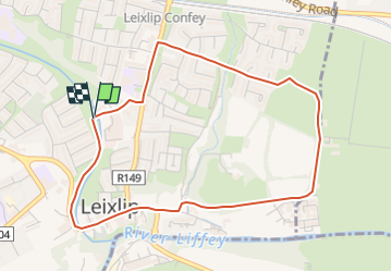
Randonnée A pied de 4 km à découvrir à Inconnu, County Kildare, The Municipal District of Celbridge — Leixlip. Cette randonnée est proposée par SityTrail - itinéraires balisés pédestres.
Description
Randonnée créée par Kildare County Council.
Localisation
Pays :
Irlande
Région :
Inconnu
Département/Province :
County Kildare
Commune :
The Municipal District of Celbridge — Leixlip
Localité :
Leixlip ED
Départ:(Dec)
Départ:(UTM)
666929 ; 5916212 (29U) N.
Commentaires
Randonnées à proximité
![Randonnée A pied Inconnu - Tymon Park Purple Slí - Photo](https://media.geolcdn.com/t/375/260/03433be3-3d1e-42a1-89f4-a324dda901d0.jpeg&format=jpg&maxdim=2)
![A pied A pied](https://static1.geolcdn.com/sitytour/trail-icons/100.png)
Tymon Park Purple Slí
A pied
Facile
Inconnu,
Inconnu,
County Dublin,
Irlande
![](/images/other/stat-length.png)
4,5 km | 5 km-effort
1h 8min
![](https://static1.geolcdn.com/siteimages/upload/files/16400158638029165_repeat_loop_refresh_sync_direction_icon.png)
Oui
![Randonnée A pied Inconnu - Tymon Park Red Slí - Photo](https://media.geolcdn.com/t/375/260/03433be3-3d1e-42a1-89f4-a324dda901d0.jpeg&format=jpg&maxdim=2)
![A pied A pied](https://static1.geolcdn.com/sitytour/trail-icons/100.png)
Tymon Park Red Slí
A pied
Facile
Inconnu,
Inconnu,
County Dublin,
Irlande
![](/images/other/stat-length.png)
3,1 km | 3,4 km-effort
46min
![](https://static1.geolcdn.com/siteimages/upload/files/16400158638029165_repeat_loop_refresh_sync_direction_icon.png)
Oui
![Randonnée Marche Inconnu - Pheonix Park and the Memorial Garden - Photo](https://media.geolcdn.com/t/375/260/ext.jpg?maxdim=2&url=https%3A%2F%2Fstatic1.geolcdn.com%2Fsiteimages%2Fupload%2Ffiles%2F1553511878bg_sport_marche.png)
![Marche Marche](https://static1.geolcdn.com/sitytour/trail-icons/101.png)
Pheonix Park and the Memorial Garden
Marche
Très facile
(1)
Inconnu,
Inconnu,
County Dublin,
Irlande
![](/images/other/stat-length.png)
14,2 km | 16,2 km-effort
3h 45min
![](https://static1.geolcdn.com/siteimages/upload/files/16400158638029165_repeat_loop_refresh_sync_direction_icon.png)
Non
![Randonnée A pied Inconnu - Hellfire - Massey - Photo](https://media.geolcdn.com/t/375/260/3668946a-ac7c-43cd-b7f0-e431097761ea.jpeg&format=jpg&maxdim=2)
![A pied A pied](https://static1.geolcdn.com/sitytour/trail-icons/100.png)
Hellfire - Massey
A pied
Facile
Inconnu,
Inconnu,
County Dublin,
Irlande
![](/images/other/stat-length.png)
3,9 km | 5,6 km-effort
1h 16min
![](https://static1.geolcdn.com/siteimages/upload/files/16400158638029165_repeat_loop_refresh_sync_direction_icon.png)
Non
![Randonnée A pied Inconnu - Massey– Hellfire - Photo](https://media.geolcdn.com/t/375/260/3668946a-ac7c-43cd-b7f0-e431097761ea.jpeg&format=jpg&maxdim=2)
![A pied A pied](https://static1.geolcdn.com/sitytour/trail-icons/100.png)
Massey– Hellfire
A pied
Facile
Inconnu,
Inconnu,
County Dublin,
Irlande
![](/images/other/stat-length.png)
6,9 km | 9,6 km-effort
2h 11min
![](https://static1.geolcdn.com/siteimages/upload/files/16400158638029165_repeat_loop_refresh_sync_direction_icon.png)
Non
![Randonnée Autre activité Inconnu - 190626Dublin - Photo](https://media.geolcdn.com/t/375/260/65430b40-93ff-440b-ac1f-885692460839.jpg&format=jpg&maxdim=2)
![Autre activité Autre activité](https://static1.geolcdn.com/sitytour/trail-icons/900.png)
190626Dublin
Autre activité
Très facile
Inconnu,
Inconnu,
County Dublin,
Irlande
![](/images/other/stat-length.png)
9,8 km | 10,6 km-effort
3h 15min
![](https://static1.geolcdn.com/siteimages/upload/files/16400158638029165_repeat_loop_refresh_sync_direction_icon.png)
Non
![Randonnée A pied The Municipal District of Clane — Maynooth - The Carton trails: Red - Photo](https://media.geolcdn.com/t/375/260/ext.jpg?maxdim=2&url=https%3A%2F%2Fstatic1.geolcdn.com%2Fsiteimages%2Fupload%2Ffiles%2F1545311037marcheuse_200dpi.jpg)
![A pied A pied](https://static1.geolcdn.com/sitytour/trail-icons/100.png)
The Carton trails: Red
A pied
Facile
The Municipal District of Clane — Maynooth,
Inconnu,
County Kildare,
Irlande
![](/images/other/stat-length.png)
3,3 km | 4 km-effort
54min
![](https://static1.geolcdn.com/siteimages/upload/files/16400158638029165_repeat_loop_refresh_sync_direction_icon.png)
Oui
![Randonnée Voiture Inconnu - Dublin 3 - Photo](https://media.geolcdn.com/t/375/260/ext.jpg?maxdim=2&url=https%3A%2F%2Fstatic1.geolcdn.com%2Fsiteimages%2Fupload%2Ffiles%2F15247431544x4.jpg)
![Voiture Voiture](https://static1.geolcdn.com/sitytour/trail-icons/401.png)
![Randonnée Marche - Dublin 1 - Photo](https://media.geolcdn.com/t/375/260/ext.jpg?maxdim=2&url=https%3A%2F%2Fstatic1.geolcdn.com%2Fsiteimages%2Fupload%2Ffiles%2F1553511878bg_sport_marche.png)
![Marche Marche](https://static1.geolcdn.com/sitytour/trail-icons/101.png)